
A Review By Benjamin Groff© Groff Media 2024© Truth Endures
As tropical activity in the Atlantic Ocean quiets down, meteorologists are turning their focus to the Caribbean and Gulf of Mexico, where conditions appear increasingly favorable for the development of the next named storm, possibly forming as early as next week. The National Hurricane Center (NHC) has officially begun monitoring this area, giving it medium odds for tropical development over the next seven days. Beyond that timeframe, forecasters from the FOX Forecast Center suggest that the potential for further intensification exists.
The outlook, however, varies across networks. FOX Weather’s Bryan Norcross reported that while the storm’s primary threat zone stretches from Panama City around the Big Bend of Florida to Sarasota, the possibility of dangerous storm surges could extend even further, particularly into Southwest Florida. Norcross emphasized that while the storm has followed predictions so far, the forecast cone might shift more than usual, leaving some uncertainty. “Nobody should be surprised by sudden changes,” he noted, highlighting the importance of staying prepared.

Meanwhile, CNN’s coverage presented a more urgent scenario, especially concerning a separate storm, Hurricane Helene, which recently prompted evacuations in Florida. Helene’s accelerated approach forced residents to brace for high winds, torrential rainfall, and potentially life-threatening storm surges. With shifts in the storm’s track possible, officials stressed the importance of preparation across the Southeast. Mandatory evacuations were ordered in several coastal counties, including Pinellas, Hernando, and Sarasota, as officials anticipated widespread impacts, including power outages and tornado threats.
While both networks offer different perspectives, the consensus is clear: residents in the affected regions must remain vigilant and ready for the worst, even if the forecast models evolve over time.
TODAY There is an Urgent Alert Out For FLORIDA And Hurricane MILTON A CATAGORY 5
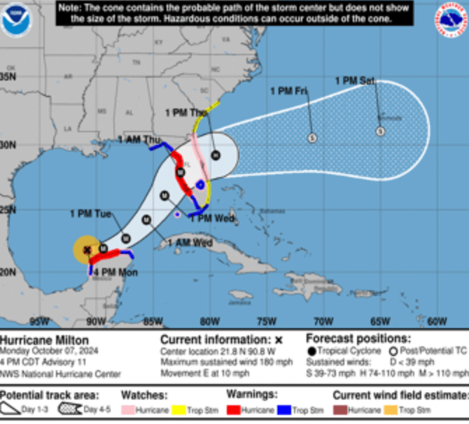
- Damaging hurricane-force winds and a life-threatening storm surge with destructive waves are expected across portions of the
- northern coast of the Yucatan Peninsula through tonight.
- Milton is expected to grow in size and remain an extremely dangerous hurricane when it approaches the west coast of Florida on Wednesday. A large area of destructive storm surge will occur along parts of the west coast of Florida on Wednesday. This is an extremely life-threatening situation and residents in those areas should follow advice given by local officials and evacuate
- immediately if told to do so.
- Potentially devastating hurricane-force winds are expected along portions of the west coast of Florida where a Hurricane Warning is in effect. Milton is forecast to remain a hurricane as it crosses the Florida Peninsula and life-threatening hurricane-force winds, especially in gusts, are expected to spread inland across a portion of the entire Florida Peninsula.
Preparations to protect life and property in the warning areas should be complete by Tuesday night since tropical storm conditions are expected to begin within this area early
Wednesday.
4. Areas of heavy rainfall will impact portions of Florida today well ahead of Milton, with heavy rainfall more directly related to the system expected later on Tuesday through Wednesday night.
This rainfall will bring the risk of considerable flash, urban, and areal flooding, along with the potential for moderate to
major river flooding

